 Google Play
An object without a record quickly becomes a thing with the backstory "found it somewhere last spring, I think". An object with a record stays a source: you can go back to the map, pull the archive file, remember why that particular conservation route was chosen, compare monitoring photos, and keep fact honestly separate from a later guess.
A find record is not a trophy shelf and not a price list. It is a personal catalogue of context that ties four layers together: the field, the map, the documents and the condition of the object. It matters even for ordinary things — mass finds are exactly what shows change in landscape, economy and time, provided you do not mix them up and do not scrub the history off along with the soil.
This is step three of the "From landscape to document" series. First a signal becomes context in the field, then the object goes through its first 24 hours — and only then comes the record that outlives a new phone, a lost memory card and your own memory.
One find, one record. One record, one chain of evidence.
Why a record matters before attribution
The first attribution is almost always incomplete. The metal may turn out to be plating, the object a fragment, the date a later one, and the historical map badly georeferenced. If the record holds only the final label "18th-century coin", it has lost the path that would let anyone check the conclusion and correct it.
| A collection-only record | A context record |
|---|---|
| Name, date, photo after cleaning | Original photo, field note, map, source of the attribution, condition and change history |
| "Silver coin" | "White metal?; photo before cleaning; attribution provisional; needs a catalogue check" |
| One vague point, "area N" | A private coordinate or landmark, a separate publicity level, and a link to the legal status of the place |
| No record of intervention | You can see when, by whom, why and with what the object was treated |
| Nothing can be verified | Every claim is tied to a photo, a map, a document, a catalogue or a confidence level |
The Canadian Conservation Institute treats archaeological collections and their documentation as a single information package: photos, notes, maps and records of what was done preserve the meaning of an object once it has left the ground. For a personal catalogue that means something simple: do not wait until you know what it is; first save what you already know.
The difference does not show up immediately. It shows up a year later, when the phone gallery holds two hundred similar frames and not one of them answers the question of where the thing came from.
Four layers of context
1. The field layer — what was observed and where
The field layer does not have to describe the whole site, but it must keep the minimum that memory cannot rebuild: the date, the general type of ground, conditions, the original look of the object, and the reason for the action or the stop. A short note on the sound and the VDI belongs here too — six months on, it explains why the signal was worked at all.
2. The map layer — where the hypothesis came from
If a historical map was used, keep the series, sheet, year, scale and a link to the scan. A map does not confirm the history of an object automatically; it explains why the hypothesis appeared. That matters later, when the overlay is refined or a sheet from a different edition turns up — see validating an overlay.
3. The document layer — what the sources confirm
An archive reply, a file reference, a museum accession number, a publication or a catalogue entry must be attached to a specific claim, not to the find in general. Do not copy a long legend into the record: keep the reference and the extract you actually need. How this layer is built in practice is shown in the map to fond to file case study.
4. The conservation layer — what happened to the object
This layer holds the original condition, photos before any intervention, every action taken, the materials used, storage conditions and monitoring checks. It protects both the object and the next researcher from repeating incompatible procedures. How often to look is covered in condition monitoring.
| Layer | The key question | Example entry |
|---|---|---|
| Field | What was visible at the moment of discovery? | "Metal object; loose corrosion; lifted on permitted ground; photo before cleaning" |
| Map | Which map produced the hypothesis? | "Red Army (RKKA) sheet…, 1:100,000, edition…; a road and a pond shown nearby" |
| Document | What confirms the conclusion? | "Archive: fond…, inventory…, file…, folio…; the document mentions the site in 1911" |
| Conservation | What was done, and how is the object changing? | "No active cleaning; stored separately; monitoring photo dated…" |
The layers are not blended. "Found it by the mill, so it is from the mill" is a map layer passed off as a document layer.
A minimum record in two minutes
Not every situation lets you fill in everything. So the record needs a short mandatory core that can be extended later — in the car, at home, a week on.
| Field | What to enter straight away |
|---|---|
| ID | A unique number, e.g. 2026-08-19-014; never use a coordinate as the identifier |
| Date and time | When the object was found and recorded |
| Original photo | General view, with a scale if possible; before cleaning and before the object is moved |
| Private location | Point or landmark plus a publicity level; sensitive coordinates are not published |
| Observation | Only what is visible: "yellow metal?", "layered crust", "fragment with a hole" |
| Action | "Photographed; bagged separately; not rinsed" or "stopped: complex context" |
| Status | "Observation", "needs assessment", "ready to catalogue", "handed to a specialist" |
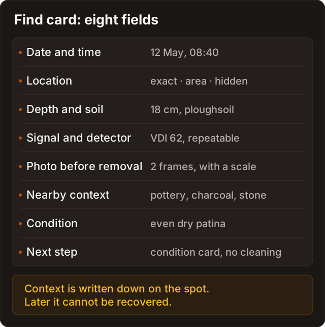
Seven lines take two minutes. Everything else can be added later; these seven cannot be reconstructed after the fact.
The full record for research and collection
When there is time, the record grows. Not every field applies to every object, but the structure must stay the same — that is the only way a catalogue stays filterable and checkable years later.
| Block | Fields | Quality rule |
|---|---|---|
| Identity | ID, working name, number of fragments, group membership | A working name must not pass a hypothesis off as a fact |
| Field | Date, general conditions, private location, type of ground, context | Do not publish sensitive points or a landowner's personal data without consent |
| Map | Series, sheet, year, scale, link, screenshot, overlay quality | The map is the source of a hypothesis, not a permission and not proof of attribution |
| Photos | Before intervention, general view, details, scale, raking light, date | Monitoring frames must be comparable with one another |
| Description | Material with a confidence level, dimensions and mass where relevant, wear, fragments | Describe what you see before you interpret it |
| Attribution | Working version, alternatives, source, who decided and when | Keep "looks like" apart from "confirmed" |
| Documents | Archive, fond, inventory, file, folio, museum number, publication | Tie every source to a specific claim |
| Conservation | Original condition, actions, materials, who did it, dates, before and after photos | Do not write "cleaned it" without saying how |
| Storage | Place, packaging, status, date of the next check | Do not put a safe code or a home address into a shared export |
| Legal and ethical status | Access checked, contact with an authority or museum needed, publication limits | A historical map does not replace this check |
The Society for Historical Archaeology describes collections storage and curation as a continuing process rather than a one-off operation: documentation is updated along with the object. A personal catalogue lives by the same rule.
Photos, coordinates and privacy
Photos and geodata are the most useful part of a record, and the part that needs the most discipline. A frame taken after cleaning does not replace the original one, and an exact coordinate in a public post can damage the place and create needless risk for you.
| Type of data | In the private record | In a public post |
|---|---|---|
| Original photos | Keep with date and ID | Publish only if they do not reveal a sensitive place and no restrictions apply |
| Exact point | Keep private, with limited access | Do not publish by default |
| General area | Keep for context | Acceptable only if it does not identify a sensitive site |
| Landowner's name and contacts | Keep only where lawful and consented | Do not publish |
| Archive copy | Keep with the file reference and terms of use | Follow the archive's or rightsholder's terms and required citation |
| Museum number | Keep exact | Publish according to the institution's rules |
A catalogue export should separate a private research file from a public record by default. In the public version the exact point, working contacts and sensitive notes are hidden automatically, not whenever the author happens to remember at the moment of posting.
Sensitive coordinates are not published. The exact find spot, a map screenshot with a crosshair and the track of the outing stay in the private file. The public record carries the object, the date, a general description and, where appropriate, an area that is not tied to a specific site.
One more habit: photograph the object so the frame can be repeated a year later. Same background, same light, same scale — otherwise before and after turns into an argument about the camera angle.
Status, confidence and the decision history
The most useful part of a catalogue is not the name of the object but the history of how knowledge about it changed. That needs simple statuses and confidence levels.
| Field | Possible values | Why it is there |
|---|---|---|
| Object status | Observation / needs assessment / stabilisation / in storage / handed to a specialist / documented in a museum | Shows the next permissible step |
| Attribution status | Undetermined / working hypothesis / confirmed by a source / needs review | Stops a casual guess from hardening into a fact |
| Confidence | High / medium / low, with a short reason | Reflects the quality of the evidence, not how sure the author feels |
| Context status | Ordinary / sensitive / restricted from publication / reported to the competent authority | Protects the place and keeps the ethics intact |
| Next step | Check the map legend / write to the archive / monitoring photo / consult a conservator | Turns the record into a working list rather than a graveyard of notes |
The confidence level is one line and always carries its reason: "low — compared only against photos online" is more honest than a bare "low".
A worked example of knowledge changing
| Date | Entry | What changed |
|---|---|---|
| 19 Aug | "Yellow metal?; fragment with a hole; photo before cleaning" | Observation; material undetermined |
| 24 Aug | "Compared with a catalogue: possibly part of a fitting; confidence low" | A hypothesis added, not a fact |
| 10 Sep | "Archive document confirms a farm building existed in the area, but not the origin of the object" | Context refined; the attribution was not upgraded |
| 20 Sep | "Conservator: no abrasives; store separately; next check …" | The safe route was updated |
Four lines, and it is clear the author did not invent the story but assembled it. That is what separates a record from a caption in an album.
Linking a find to archives and conservation
A record gets its strength from not mixing different kinds of evidence.
| What turned up | Where the record should lead |
|---|---|
| An unusual symbol on the map near the spot | To reading map symbols and validating the overlay: the map raises the question |
| A document about a mill, a road or a house | Into the document context field, not into object attribution unless a direct link exists — see the archive case study |
| Loose corrosion, plating, glass, organics | To the first 24 hours and to water, salts and hydrolysis |
| A significant or contested situation | To the procedure on finding something and the local procedure, without publishing the exact point |
| A finished scholarly attribution | Into the confirmed attribution field, with a reference to the catalogue, the specialist or the publication |
An important limit. An archive document about a place does not prove the origin of every object found in that area. It can explain the historical context, but the link between the document and a particular object has to be argued separately — until then it stays a hypothesis.
The reverse holds too: an object does not confirm a map. A button beside a symbol marked as an inn does not prove the inn stood here. It proves a button was here.
The find diary in Discovera
In the app the record lives in the find diary: photos, the location, the historical map layer and the notes end up in one entry instead of three different places. The practical value is not the interface but the fact that the fields exist in advance and are hard to forget.
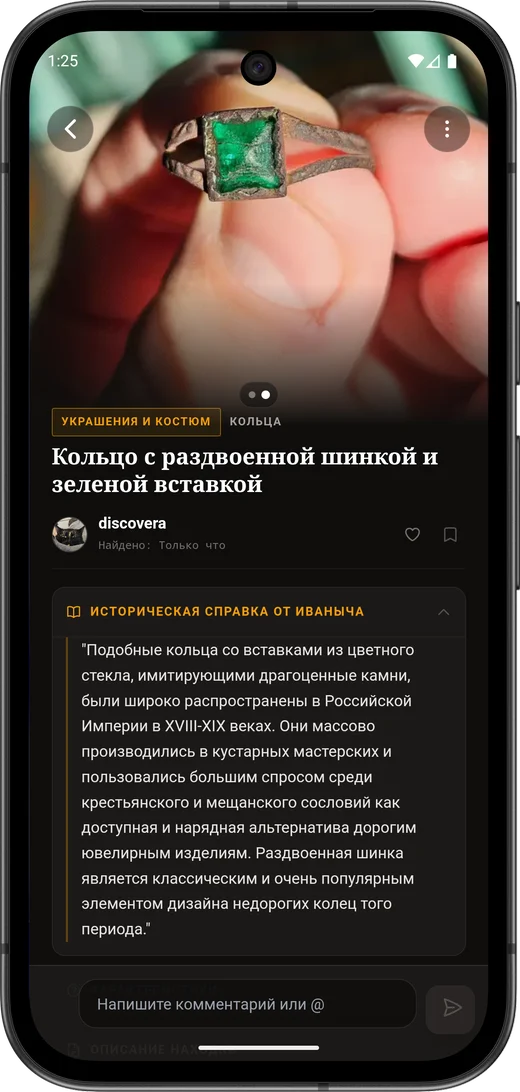
A separate setting is location precision. It decides not how the entry looks but what an outsider sees.
| Precision level | What is stored and what is visible | When to choose it |
|---|---|---|
| Exact | Full coordinate in the private file; not shown in the public record | Ordinary finds on your own or permitted ground, where the point matters to you |
| Area | An approximate location, enough for context | When the place could attract unwanted attention but a general area gives nothing away |
| Hidden | The coordinate appears nowhere except the owner's private file | Sensitive context, a contested situation, any place where publicity creates risk |
The order is one-way: start at hidden and relax the level once you are sure it is safe. You can always reveal a point; you cannot un-publish one.
A find photo can be run through Discovera's AI analysis: it narrows the range of hypotheses and previews a restoration without touching the original. The result belongs in the working version field, not in confirmed attribution.
Law and ethics. A precision level is privacy, not permission. Neither an app setting, nor an old map, nor an empty line in a register gives you the right to search a particular plot. If there are signs of a cultural layer, a burial or ordnance, work stops, the object and the place are left alone, and the local procedure takes over — see safety and legal status.
Record template
The template is easiest to keep as a note on the phone: dictate it in the field, transfer it into the catalogue at home.
Identity
ID: YYYY-MM-DD-NNN- working name, neutral
- number of fragments, group membership
Field observation
- date and time
- private point or landmark, precision level
- original description — visible features only
- photos before any intervention
- what was done and what was deliberately not done
Map context
- series, sheet, year, scale
- what exactly was noticed on the map
- overlay quality and control points
Attribution
- working version
- alternatives
- confidence level and why
- source of the check
Document trail
- archive, museum or library
- fond, inventory, file, folio or accession number
- a short verifiable extract
- terms of use for the copy
Condition and conservation
- material and condition
- stop signals
- actions, materials, dates, who did them
- storage conditions
- date of the next check
Publication
- precision level of the coordinate
- restrictions and consents
- what goes into the public version of the record
What to read next
- Signal, mark, context — what to record before the object is in your hand.
- The first 24 hours after a find — the original documentation and the stop signals.
- Water, salts and hydrolysis — how to connect condition to a safe decision.
- Condition monitoring — scheduled checks and the change log.
- Archive case study: map, fond, file, conclusion — how to add the document trail.
- Archives of Russia and Belarus — where to send a request and what to put in it.
FAQ
Do I need a record for every ordinary object?
Yes, at least a minimal one. Mass finds lose their value fastest without a date, a place and an original condition: a year on, ten identical buttons from different places are just a handful of buttons from nowhere. The full record can be filled in later.
What do I call an object when I do not know what it is?
Use a neutral working name: metal fragment, glass fragment, object with a hole. Put the attribution in its own field with a confidence level — then it can change without rewriting the whole record.
Can I link an object to a feature on an old map?
Recording the map context as a hypothesis is both allowed and useful. But neither a map nor an archive document about a place proves the origin of a particular object without a direct link: a matching area is a question, not an answer.
What if there is no photo from before cleaning?
Do not reconstruct one and do not pass a later frame off as the original. Add current photos, note honestly in the record that the original documentation is missing, and start a condition log from that moment — at least there will be something to compare against.
How do I avoid losing the catalogue when I change phones?
Export the private research file regularly, keep the original photos away from messengers, which recompress frames, and check that record IDs match the file names. A public export must not contain exact coordinates or working notes.
Should the whole record be published?
No. The public version is the object, the date, a general description and a deliberately chosen precision level. The exact coordinate, the landowner's contacts, references with restricted terms of use and notes about contested situations stay in the private file.