 Google Play
In detecting conversations a test pit usually means “a small hole to check the spot”. In archaeology it means something else entirely. A test pit is a research procedure that begins with a question, a legal basis, a named project lead, a recording system, a risk assessment and a defined way of finishing. Its point is not to reach an object faster but to understand what is in the ground, in what order, and why it is there.
This article is not a manual. There is no site selection here, no setting out, no dimensions, no depths, no layer-removal technique: all of that belongs to work carried out under permit and under a specialist’s responsibility. What follows explains why archaeology needs test pits, what exactly gets destroyed by unauthorised digging, and where the line runs that a hobbyist must not cross.
Disclaimer. This is an educational explainer, not legal advice. Requirements differ by country, region and land status, and they change over time. Check the current wording of the rules before you go out, and contact your regional heritage authority when in doubt.
For a hobbyist the distinction is fundamental. An old map, a confident signal, a potsherd in the ploughsoil or a visible foundation all feel like reasons to “look deeper”. They are in fact reasons not to widen the intervention: record what you can see and follow the local procedure. A map tells you about the past; legal status decides what you may do in the present.
In short: a neat plug cut for an ordinary, permitted find and a test pit are not the same thing. The moment work turns from lifting a single object into opening up and interpreting soil, layers or structure, it demands a different level of legality, responsibility and documentation.
What archaeologists mean by a test pit
A test pit is a limited research excavation of the ground, carried out to answer a specific question about stratigraphy, preservation or the character of a site. In training and professional programmes it is tied to a question set in advance, a risk assessment, context recording, photography, reporting and reinstatement of the ground afterwards. The UK project Dig School describes test-pitting as a chain of “question — permission — record — report” rather than as earth-moving; Peterborough Archaeology in its test-pitting notes makes the point that all of it happens inside an organised project with named responsible people.
So “let’s put in a test pit” is not a decision one person makes in a field. It is made before the trip, together with the justification, the permission, and the plan for what happens to the soil, the finds and the records afterwards.
| Ordinary careful work in permitted detecting | Archaeological research work |
|---|---|
| Solves the local task of lifting a single ordinary object where that is lawful and agreed | Studies the soil, the sequence of layers, structure, the relative position of features and samples |
| Must not turn into widening the hole or investigating layers | Requires a research aim, professional method, permits and full documentation |
| Ends with careful reinstatement of the ground and a record of the find | Ends with context records, reporting, secured preservation of materials and reinstatement within the project |
| Stops at the first signs of a complex context | Operates only within the agreed project and its established procedures |
This line is not bureaucracy. An archaeological object matters for more than its material or its looks. Its position, depth, neighbouring features, layer boundaries, traces of organics and relationship to the landscape explain how the thing was used and why it ended up here. The Canadian Conservation Institute stresses that objects and their associated records — photographs, field notes, maps, data — form a single archive: decisions taken in the field in one minute affect that archive for decades.
Why an object without context loses part of its meaning
Picture two coins that look identical. One was found as an isolated late object in mixed ploughsoil. The other lay beside pottery fragments, structural elements and a group of other things in a legible layer. Externally they are nearly the same object, but the second carries far more information. And once the hole has been widened without thought, no “after” photograph restores the difference.
Context is not a coordinate. It is a combination of observations that lets a specialist read an object without guessing. How to hold on to context with an ordinary permitted find is covered in from signal to find.
| What counts as context | Why it matters |
|---|---|
| Position and orientation of the object | Shows whether it lay there by chance, as part of a structure, or within an assemblage |
| Character of the surrounding soil | Lets you tell recently disturbed ground from a more complex situation |
| Neighbouring objects and materials | Help establish whether the find is isolated or linked to other features |
| Visible signs on the site | Foundations, masonry, an unusual concentration of material, surviving organics all change the assessment |
| Map source and its year | Do not prove status, but explain where the hypothesis about the place came from |
The working rule is simple: the more observable signs add up to one assemblage, the less justification there is for carrying on alone. The observations are not lost — they belong in a find record, not in a widened hole.
What lawful research work is made of
Even training test-pitting projects do not start with a tool. They start with a research question, the landowner’s written consent, a permit document, a safety assessment, an allocation of roles, a recording system and a plan for handling the material. The specific requirements shift from country to country, region to region and with the status of the land, so this article does not replace local law or the conditions of a particular permit.
| Required element | What it is for |
|---|---|
| Legal basis and written agreement | Land, protection zones, monuments and heritage assets all carry different statuses; the absence of a visible prohibition is not permission |
| A research aim | Limits the intervention and shows which data is actually needed |
| A responsible lead and defined roles | Secures decisions on safety, documentation, preservation and transfer of material |
| Risk assessment | Accounts for services, ground stability, weather, people, dangerous objects and other threats |
| Recording of layers and observations | Preserves the sequence and relationships that the intervention itself destroys |
| Preservation and completion plan | Covers handling of fragile material, reporting, transfer of finds and reinstatement of the ground |
None of these elements appears by itself for a private person with a spade. That is precisely why “I will dig a careful test pit” is no more lawful than “I will dig a rough one”: care does not substitute for a basis.
In Britain the Portable Antiquities Scheme shows the value of recording finds made by the public properly: its database turns individual reports into material for landscape research. It is not a universal legal model for other countries, but it is a good illustration of why a recorded find is worth more than a secret spot.
The permit regime: Russia and Belarus
This section is written for readers who search in Russia or Belarus. It grants nothing and judges no particular case — its job is to show that searching for archaeological objects there runs on a permit regime, not a notification one.
| Question | Russia | Belarus |
|---|---|---|
| What governs protection | Federal Law No. 73-FZ on objects of cultural heritage | Chapter 17 of the Code of the Republic of Belarus on Culture |
| Who may carry out identification and study | The holder of an Open Sheet permit (otkryty list): the Ministry of Culture issues them for work that includes searching for and removing archaeological objects | A participant in archaeological research conducted under a permit from the National Academy of Sciences of Belarus |
| What owning a detector means | A metal detector by itself is not permission: the assessment depends on purpose, the nature of the actions, the status of the place, access rights and whether archaeological objects were removed | Using metal detectors, ground-penetrating radar or other means to search for archaeological objects and artefacts is prohibited, except for a permit holder and participants in the research (Art. 127 part 7 of the Code on Culture) |
| Where to check the status of a place | EGROKN, the unified state register, is the main source on heritage assets, their territories and protection zones; when in doubt, the regional heritage authority | The local executive and administrative body; official guidance on the protection of archaeological heritage |
| On a chance discovery | Follow the local procedure: unlawful searching for and/or removal of archaeological objects falls under Art. 243.2 of the Russian Criminal Code | Take measures to preserve it, halt any action immediately, and notify the local executive and administrative body in writing within two calendar days; hand a movable valuable to the city or district executive committee for temporary storage |
Checking the register is an important step, but not an exhaustive one. An empty result from a single source does not mean the plot is free of archaeological context: registers record identified assets, not every asset that exists. No single indicator — “the field is open”, “there is no sign”, “the register is empty” — makes anything lawful on its own. The regime is unpacked in detail in metal detectors and the law: Russia and Belarus.
Where the line runs for hobby detecting
A responsible detectorist does not have to be an archaeologist to act carefully. Their strong position is checking the status of a plot in advance, getting consent where it is needed, following the rules, not publishing sensitive coordinates, reinstating the ground properly and keeping a log. What they must not do is convert a potentially complex situation into an excavation on their own initiative.
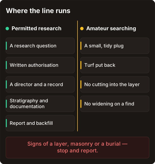
The line is not drawn by spade size or by depth. It is drawn where an action starts to destroy or interpret layers, structure or an assemblage instead of lifting a single permitted ordinary object. At that moment the work stops and the decision passes to whatever procedure the region provides.
| Situation | Safe and responsible action |
|---|---|
| An ordinary find in a permitted place with no signs of complex context | Work carefully, do not widen the intervention, reinstate the ground and log the find |
| Unclear layers, a structure, foundations, masonry or a marked concentration of material | Do not widen the work; record what is visible without going further and check the local reporting procedure |
| A possible burial, human remains, or objects associated with them | Stop immediately and contact the competent services under the rules of your region |
| Ordnance, an explosive or a suspicious object | Do not touch, move or try to identify it; withdraw, mark the spot safely and call the relevant services |
| An object with organics, enamel, glass, textile, leather or a fragile construction | Do not clean it in the field, do not “test” it with chemistry and do not separate parts; stabilise the situation without active treatment and consult a specialist |
Law and ethics. An old map issues no permission, and an open field does not cancel a protection regime. At any sign of a cultural layer, a burial or ordnance the work stops at once and continues through the local procedure — however convincing the hypothesis looked.
The last row of that table matters just as much for conservation. Waterlogged organics, glass, heavily corroded metal and composite objects suffer from an abrupt change of environment alone. Amateur cleaning “just to see what it is” destroys more information than it saves — see restoration principles for finds.
Stop signals: when the intervention must not widen
Not every unusual signal means an archaeological site, but a cluster of indicators calls for caution. The point of stop signals is not to let you diagnose a monument yourself; it is to keep you from making things worse if you were wrong. And it is better to be wrong on the safe side.
| What you notice | Why it is a reason to stop |
|---|---|
| Several objects or mixed materials within one small context | It may be a linked assemblage that must not be separated without recording |
| Distinguishable soil layers, unusual structure, stone or brick masonry | The information sits not only in the objects but in the sequence and boundaries of layers |
| Traces of wood, leather, textile, bone, glass, enamel or other fragile materials beside metal | Different materials need incompatible handling conditions and break down under amateur treatment |
| Signs of a burial, remains, military features or dangerous objects | Separate legal procedures and safety requirements apply; intervention is not acceptable |
| A sense that the area may be protected or tied to a heritage asset | Even a good historical hypothesis does not override a protection regime or a permit requirement |
Doubt is reason enough to stop. You do not have to prove to yourself that a situation is “definitely archaeological” in order not to take the next step. The cost of stopping wrongly is a find you did not make; the cost of continuing wrongly is destroyed context and legal consequences.
On-site conduct, including handling dangerous objects and closing holes, is collected in safety and ethics.
How to preserve an observation without digging
Stopping does not mean losing the value of the observation. The opposite: careful recording keeps a later assessment possible. What to do when you find something sets the right order — do not clean the object on the spot, fix the point and position, take a wide shot and a close-up without publishing the exact pin, then follow the local procedure.
What follows is not an excavation guide but a minimum protocol for preserving information, one that adds nothing to the intervention.
| What to record | What it gives you |
|---|---|
| The general view of the place and the nearest landmarks | Makes the location understandable without publishing exact coordinates |
| A photo of the visible state, without cleaning or moving anything | Preserves the original picture for a specialist to assess |
| Time, date, map source and general character of the plot | Shows how the hypothesis arose and what the conditions on site were |
| What exactly made you stop | Makes the decision legible: concentration of objects, structure, danger, protected status |
| Who was informed and when | Supports an honest record of what you did next |
Reading a map helps you describe a place in words rather than coordinates: topographic symbols give you the vocabulary for a log entry such as “edge of the old estate boundary by the ford”. If an authority or a specialist asks you to leave the place untouched, follow the instruction. In that case the field log becomes a record of good faith, not a claim on the object.
If an object was lawfully lifted and turns out to be fragile, the first 24 hours after a find take over: environment, humidity and packaging decide more than any cleaning.
Reinstating the ground: whose duty it is
Inside an archaeological project, reinstatement is not a courtesy — it is part of the method. It is written into the work plan before anything is opened: who is responsible, in what condition the land goes back to its owner, what the report says, where the material is deposited. Without that the project counts as unfinished.
For a hobbyist exactly one thing follows from this. The principle “leave the ground as you found it” exists inside a permitted project and does not work as an indulgence outside one. A neatly backfilled unauthorised hole is still an unauthorised excavation: restoring the surface does not restore the destroyed stratigraphy and does not change the legal assessment of what was done.
So in ordinary permitted detecting, reinstatement is about the turf over an ordinary plug and about respect for the landowner. Any reasoning along the lines of “so nobody notices” already sits outside the hobby and outside this Academy.
How Discovera helps
Discovera is useful here not as a “where to dig” tool but as a discipline of observation. The historical overlay records which map sheet the hypothesis came from. The find card holds photos and notes. A private pin and the log fields keep the context from getting lost. But the app issues no permissions, determines no protected status and does not replace a conversation with an archaeologist or a heritage authority.
| Feature | Correct use |
|---|---|
| Historical layer | Record the source of the hypothesis and the year of the sheet — not declare the plot permitted |
| Find card | Keep the pre-cleaning photo, the time, the observation and the status of what happens next |
| Private pin | Avoid losing a place that needs lawful reporting; do not publish a sensitive pin |
| AI photo analysis | Get a careful hypothesis from an image — it does not replace physical assessment of the object or its context |
FAQ
Is a test pit just a deep plug?
No. In the archaeological sense it is a research method bound to an aim, a permit, layer recording, safety and reporting. It cannot be reduced to the size or depth of a hole: what differs is not the shape of the opening but the basis for the work and the responsibility for the result.
An old map shows a manor. Does that justify a test pit?
No. A map is a historical source, not permission. First you check the status of the area, the right of access and local requirements; at any sign of complex context the intervention does not widen. A map hypothesis stays a hypothesis until someone entitled to test it does so.
I found a dense concentration of finds. Should I “carefully look a bit more”?
No. The density and relative position of the objects may be the most important information there. Stop, do not clean or separate the objects, record what is visible and move to the local procedure. This is exactly the situation in which widening the work destroys data fastest.
If I photographed everything, can I continue?
Photography helps but does not restore destroyed context. Images do not replace layer recording, a safe work plan or a permit. In a doubtful situation a photo is a way to preserve information before you stop, not permission to carry on.
What do I do with an object after a lawful lift?
Do not clean it in the field and do not use active agents, especially when the material or its condition is unclear. Take a photo, keep it apart from other objects, preserve the accompanying record, and then work from restoration principles for finds and preservation.
The land is private and the owner does not mind. Is that enough?
No. The owner’s consent settles the question of access to the land, but it does not cancel the archaeological heritage protection regime or the permit requirement for works. These are two separate checks, and the second does not follow from the first. A verbal “dig away, I don’t care” is neither an agreement nor a permit.
See also
- Legal status — why a map and a permit answer different questions.
- Metal detectors and the law: Russia and Belarus — the permit regime and the checks to run before you leave.
- What to do when you find something — how to act in a significant or disputed situation.
- Safety and ethics — dangerous objects, closed holes and respect for the site.
- Topographic symbols — reading a map without turning a hypothesis into permission.
- From signal to find — context for an ordinary permitted find.
Sources
- Dig School — Excavate a Test Pit and Report My Dig
- Peterborough Archaeology — Test-Pitting
- Canadian Conservation Institute — Caring for archaeological collections
- British Museum — Treasure and the Portable Antiquities Scheme
- Official Legal Information Portal of Russia — Federal Law No. 73-FZ
- Ministry of Culture of Russia — issuing of Open Sheet permits
- National Legal Internet Portal of Belarus — Code on Culture
- Vitebsk City Executive Committee — protection of archaeological heritage