Text on an old map is not decoration. The name, the abbreviation, the type size, the slant, the placement — even the spacing between letters — can all belong to the sheet's conventional language. A map may skip the pictogram for an object and name it with an abbreviation instead. Or it may set a name so that the graphics themselves tell you what kind of place this is: a town, a village, an abandoned tract, a water body, a forest compartment, a farm building or an administrative unit.
The most common mistake is to see familiar letters and immediately swap in a modern word. The same abbreviation can carry different meanings across series, scales and languages. The National Library of Scotland says as much plainly: its Ordnance Survey abbreviations list is compiled from sources covering different scales and territories, and without knowing the series it does not work.
This is step three of the “Language of the old map” series. Step one is topographic conventional signs, the grammar of the legend. Step two is roads, crossings and linear features. What is left is the text.
Rule. First transcribe the label exactly as printed. Then establish the series, language, year and scale. Only then expand the abbreviation — and record how confident you are.
Why map text is a data layer of its own
On a topographic sheet, text separates objects that look identical at a glance. A label can specify the type of place, the name, an elevation, an administrative status, the function of a structure, the character of a road or of water. Depending on the scale, some objects are shown by a graphic sign, some by a label, and some by both — the smaller the scale, the more work falls to the text.
| Part of the label | What it can carry | What to check |
|---|---|---|
| Full name | A toponym, the name of a farm, a tract, a feature or a district | The language, the period spelling, the wording on neighbouring sheets |
| Abbreviation | Object type, function, administrative character, technical note | The legend, the reference list for this series specifically, the scale and the year |
| Type size | The relative rank or size of the object within this particular map | The characteristic sheet or the legend; a rule from one series does not transfer to another |
| Slant and direction | A link to a river, a ridge, a road, a square or a bounded area | Which object the label belongs to, and whether it crosses several of them |
| Colour or print style | A thematic layer, a late correction, a departmental object, an editorial difference | The date of issue, overprints, the colour key |
| A number or code | Elevation, road number, distance, compartment, sheet number, administrative index | Units of measurement, the sheet margin, the legend and the coordinate system |
Words on a map sometimes preserve what modern toponymy has dropped: an old village name, a vanished farmstead, a former trade, an obsolete administrative unit. But text records the cartographer's vocabulary and view at one moment — no more than that. Graphics are covered in topographic conventional signs; text is read together with the signs, not instead of them.
What a map label is made of
It pays to break a label into parts. That lowers the risk of an unclear word being completed by imagination: the brain is very willing to fill missing letters up to a word it already knows.
| Layer | Question to put to the label | Example diary entry |
|---|---|---|
| Original | Which letters, diacritics, abbreviations and marks are actually visible? | “original: Folw.; the last character is uncertain” |
| Language and script | Which language, and in which script? Is there any mixing? | “Polish Latin script; German administrative labels alongside” |
| Function | Is this a place name, an object type, a spot height or a service code? | “probably a farm-building type, not a toponym” |
| Expansion | What confirms the expansion of the abbreviation? | “from the series legend, from the map dictionary, from a neighbouring sheet” |
| Confidence | Fact, supported hypothesis or guess? | “medium: matches the reference list, but the legend for this edition was not found” |
These five layers — original, language, function, expansion, confidence — work better than a long list of someone else's abbreviations with no context. A list hands you an answer; the layers hand you a checkable route to one. Six months on you will remember not the conclusion but what it rested on.
Expansion, transliteration and translation are three different operations
These get mixed together far too often. They answer different questions and belong in separate fields of the record.
| Operation | What it does | Example of the principle | Risk |
|---|---|---|---|
| Expanding an abbreviation | Unfolds the form used in this particular series | St. is expanded only after checking the series dictionary | One form can carry several meanings |
| Transliteration | Carries a spelling from one alphabet into another | Cyrillic into Latin with the meaning untouched | The toponym acquires a spelling found in no source |
| Translation | Carries the meaning of a word into another language | A German or Polish term into its English equivalent | Translation drops the historical status or the technical sense |
| Modern equivalent | Ties an old name to a present-day one | Old toponym to modern name, where the link is confirmed | The highest risk of all: one name may have covered several places |
Keep all four layers in the diary where they apply: the original, the rendering in another alphabet, the literal translation and the modern hypothesis. Then the next reader — or you a year from now — will not mistake a translation for the primary inscription.
Lettering, placement and old scripts
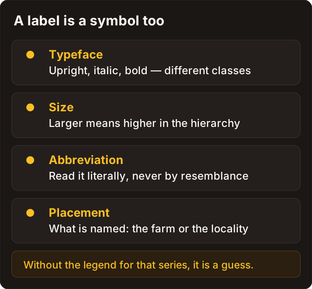
Map lettering is often organised as part of the legend. On some maps a large upright face marks a settlement, italic marks a natural landscape feature, letter-spacing marks a large area, and a label running along a blue line marks a river. On other series the rules will differ. The National Library of Scotland keeps separate characteristic sheets for Ordnance Survey, with samples of the lettering as well as the signs, for different scales and periods. That is the proof that typography is read inside a tradition, not by a universal rule.
| Observation | Possible working hypothesis | How not to get it wrong |
|---|---|---|
| The label follows the bend of a water line | It refers to a watercourse or water body | Check the colour, the placement and the neighbouring hydrographic signs |
| The text sits inside a wood or marsh outline | It characterises an area feature | Find the boundary of the area and the vegetation legend |
| The name is set larger than its neighbours | The object ranks higher within this series | Compare with several known objects on the same sheet |
| Italic or letter-spacing differs from the ordinary label | A different class of object, or an editorial layer | Find a lettering sample for the series, or comparable cases nearby |
| The text is printed over another colour | A late correction or an overprint | Check the date of issue, the date of correction and the layer's conventional signs |
Old scripts are a difficulty of their own. Pre-revolutionary Russian sheets carry letters that no longer exist in the modern alphabet, and the habit of quietly correcting them destroys the original form. Early German sheets are set in a historic type where several letters are easy to confuse. The rule is single: transcribe as printed first, including characters you cannot read and question marks where letters are lost, and only then produce a modern form — on a separate line.
Lettering helps you ask the question; it does not close the answer. Reliability appears when the typographic clue agrees with the legend, with the object on the ground and with other sheets of the series.
From observation to verification
It helps to run the same route every time: what is visible — what follows from it — what checks it. The third column is the important one: without it, a hypothesis turns into a “fact” within a week.
| Observation | Hypothesis | Verification |
|---|---|---|
| An abbreviation sits beside a drawn farmyard | It marks a type of farm building | The legend or the series reference; whether the same form carries the same meaning on neighbouring sheets |
| A name is set larger than its neighbours | The object ranks higher administratively | Compare with three to five objects on the same sheet whose status is known |
| A label runs along a blue line | It belongs to the watercourse, not to the nearest farmstead | Colour, hydrographic signs, relief and water on historical maps |
| An old name resembles a modern one | It is the same place | Archival lists of settlements; archives of Russia and Belarus |
| The inscription is printed over another colour | A late correction or an overprint | The survey year and the correction year of the sheet; RKKA and General Staff maps |
| A labelled line looks like a road | It is a road of that class | The class of the line per the legend and its continuation on adjoining sheets; roads and linear features |
| The labelled object is absent from modern imagery | The object is gone | The quality of the georeference and the shift of the layer; overlay without self-deception |
| Text recognition returned a confident word | That is what is written | Character-by-character comparison with the image; where they disagree, the original stands |
What a map does not prove
Text on a sheet is a strong source and weak evidence. The distance between those two words is the whole discipline of working with maps.
A map does not prove. A label says one thing only: the cartographer recorded the object this way when the sheet was compiled. It does not say the object was there in the year of issue, that it was there only then, that it survives today, or that you may walk up to it.
- The sheet date is not the object date. Some content is carried over from earlier surveys and some is corrected later; the year in the margin is the year of issue, not the year of everything drawn on it.
- A name is not a function. A mill in the name of a tract can outlive the mill itself by a century, and a church name can remain long after the building was taken down.
- An abbreviation is not a meaning until you have found the legend, the characteristic sheet or the reference list for this series specifically.
- The presence of a label is not survival. Between the map and today came ploughing, drainage, construction, a reservoir.
- A map is not a permit. No sign and no inscription changes the legal status of a parcel.
Law and ethics. An old sheet is a source, not a pass. The status of the land and of the object is checked separately: legal status and regional differences. If the site shows signs of a cultural layer, a burial or ordnance, work stops at once and the local procedure takes over from curiosity.
Reading map text across countries and periods
A foreign map does not require memorising hundreds of foreign words. It requires discipline: first establish which language the map speaks, then keep administrative, topographic and functional words apart.
| Tradition | What to watch for in particular | A practical first step |
|---|---|---|
| Pre-revolutionary Russian maps | Pre-reform spelling, period abbreviations, old administrative and estate names | Keep the original spelling without “correcting” it into modern orthography |
| Red Army (RKKA) and Soviet sheets | Abbreviations, departmental notation, spot heights, corrections and editorial layers | Check the survey year and the correction year before comparing with a modern name, see RKKA and General Staff maps |
| Polish WIG sheets | Polish orthography, local administrative and estate terms, possible German, Ukrainian and Belarusian names nearby | Separate the toponym from the object type; do not translate on the strength of similar letters |
| German Messtischblatt | German abbreviations, historic type on early sheets, later corrections | Identify the script and the series first, then go to a specialised reference |
| British Ordnance Survey | Notation that depends on scale and period, a developed system of abbreviations | Use the OS abbreviations list and check the scale of the sheet |
| American USGS | Conventional signs, abbreviations and lettering styles that changed over time | Check the sheet date and its symbol sheet: USGS separately explains where to find one |
A large bilingual glossary is not what you need here. A living card library works better: one sign or abbreviation, one verified example with the series, year, scale, original inscription, expansion, source and level of confidence. It grows with the maps you actually work through, and holds quality better than a context-free list.
Five mistakes when expanding a label
| Mistake | Why it happens | The better practice |
|---|---|---|
| Correcting old spelling before recording the original | You want the text to look familiar | Save the exact wording first; add the modern form on a separate line |
| Translating an abbreviation from one familiar word | The letters look obvious | Check the legend and the series dictionary, and look at comparable cases nearby |
| Taking text recognition for map reading | An automatic reader invents its way through old type | Compare the output with the image character by character |
| Merging the name and the object type | The label looks like a single word | Mark which part is the toponym and which is the classification |
| Presenting an expansion as fact with no source | The answer looks plausible | State the source and the level of confidence; when in doubt, leave it as a hypothesis |
A separate word on machine help. Text recognition and AI are useful as hypothesis generators: they offer options quickly where the eye stalls. But they have no access to the legend of your sheet, and the confident tone of an answer says nothing about whether it is right. The order is: original and sheet passport first, the machine version second as one hypothesis among others, then verification against a source. How this works in the app is covered in AI cases in Discovera.
A map dictionary in Discovera
A record in the app turns a difficult inscription into checkable knowledge. What matters is that it never erases the original.
| Field | What to store |
|---|---|
| Image of the fragment | A screenshot or photo with context around the inscription, not the word cut out of it |
| Original form | An exact transcription of letters, abbreviations, question marks and uncertain characters |
| Series and sheet passport | Country or service, survey year, year of issue, scale, sheet number, link to the archive |
| Language and script | For example: Polish Latin script, pre-reform Cyrillic, German historic type |
| Expansion | Only in the wording confirmed by a source |
| Translation and modern equivalent | Kept apart from the original, with a level of confidence |
| Verification source | The legend, a characteristic sheet, an archival reference, a neighbouring sheet |
Such a dictionary serves more than one person. It assembles the Academy's future library of “how we know this sign means this”. In moderation, each card can be marked as checked by the editors, confirmed by a source, or left open as a question for the community.
Recording discipline. The original and the expansion live in different fields. The moment they are glued into one line, the original inscription can no longer be recovered — and it is the original that is the primary source.
Where to go next
- Topographic conventional signs — the grammar of the legend, where the series starts.
- Roads, crossings and linear features — how to check the lines that most often carry abbreviations.
- Reading historical maps — Shubert's three-verst map, versts, scale and georeferencing.
- RKKA and General Staff maps — abbreviations and editorial layers on Soviet sheets.
- Overlay without self-deception — matching an old sheet to a modern map without trusting the shift.
- Historical maps on your phone — where to read the sheet in the field.
- Visual identification of finds — the same hypothesis-and-confidence discipline, applied to objects.
FAQ
If an abbreviation looks obvious, do I still need the legend?
Yes, and especially on a historical map. The same letters mark different object types at different scales and in different series. What feels obvious is usually a match with a modern word rather than with the language of the sheet.
Can I replace an old toponym with the modern name straight away?
Only as a separate hypothesis in a separate field. Save the original form first, then state which source establishes the modern equivalent. One and the same name often covered several neighbouring places.
Why does lettering matter at all?
Because on many series the size, slant and placement of text separate classes of objects as well as pictograms do. But that language is not universal: it is confirmed by the characteristic sheet of the specific series, not by a habit carried over from another map.
What do I do when the text is illegible?
Save the fragment, the sheet passport and several neighbouring labels for comparison with the series' hand. Do not draw in letters you expect to be there. Sometimes the answer only appears after comparing another edition, or a better scan of the same sheet.
Can AI be used for the expansion?
Yes, as an assistant that produces a hypothesis. The original image, the series and the legend still outrank an automatic answer. Store any machine expansion with a note on the source and the level of confidence.
Is a label on a map a reason to go out to the site?
It is a reason to keep researching: adjoining sheets, archival lists, modern imagery. A label carries no legal weight — access, land status and the status of the object are checked separately, and before you travel.
Sources
- National Library of Scotland — Ordnance Survey abbreviations
- National Library of Scotland — Ordnance Survey characteristic sheets
- U.S. Geological Survey — where to find a topographic map symbol sheet
- Archiwum Map Wojskowego Instytutu Geograficznego — WIG sheets
- The National Archives — historical maps and plans