 Google Play
A Soviet military topographic sheet looks convincing: roads, streams, spot heights, buildings, bridges, ground types, boundaries, a coordinate grid. That is exactly why it is so easy to read it with too much confidence. A sheet is not a snapshot of the ground, and it is no guarantee that every line will land on modern satellite imagery. It is a historical document: compiled and printed in a particular period, under particular rules, with permissible cartographic generalisation and, often, with revisions made at different times.
What follows is the working order for a single sheet: edition data, scale, nomenclature, the border, the symbols, the revision layers, and an honest assessment of the overlay. The underlying language of symbols is covered in topographic symbols; the general logic of working with an old map is in reading old maps.
Read the sheet's edition data, its border and its legend first. Only then interpret any feature on it.
This article deals with Red Army (RKKA) material and the later Soviet General Staff tradition. Sheets of the same scale, and even of the same region, differ in survey year, printing year, symbol system and degree of revision. The primary source is always the specific sheet and its manual, never a general impression of “General Staff maps”.
What counts as an RKKA sheet and what counts as a General Staff sheet
In everyday speech “a General Staff map” means almost any Soviet military topographic map. For research that is not enough. What matters is the concrete imprint: the issuing body, the series, the scale, the survey date, the compilation date, the revision date, the year of printing and the condition of the sheet. Between the Red Army, the Soviet Army and later editions there is both continuity and difference; they cannot be reduced to one universal legend.
The digitised manual of the Military Topographic Directorate of the General Staff, reissued in 1967, covers the symbols and map samples for scales from 1:25,000 to 1:1,000,000, and accounts for the differences between the symbols adopted in 1963 and the earlier ones of 1959. It is a convenient anchor for reading sheets of that tradition, but not a licence to carry every symbol across to a map from another decade without checking.
| What the sheet record says | What it means for reading |
|---|---|
| RKKA, pre-war edition | Check the language, the orthography, the period symbols, the year of the original survey and any later reprints |
| General Staff, post-war Soviet edition | The printing year, the revisions, the specific edition and the legend then in force all matter |
| A sheet from a third-party collection with no imprint | Use it as a lead only; look for a good scan with the border and full imprint first |
| An assembled mosaic or a crop of a map | Convenient to view, but it can hide the nomenclature, the year, the adjoining sheets and important border data |
Sheet passport: eight items before any analysis
Before you work on a feature, build a passport for the sheet itself. It takes a minute and removes most of the errors of the “the map is old”, “the road was definitely there”, “the layer lined up perfectly” kind.
| Item | What to record | Why it matters |
|---|---|---|
| Name and nomenclature | For example, M-36-136 — exactly as printed | Helps you find adjoining sheets, another edition and the catalogue |
| Scale | 1:25,000, 1:50,000, 1:100,000 and so on | Sets the level of detail and what may legitimately be measured |
| Year of the source data | Survey, compilation, correction, printing — where they are given separately | Stops you attaching the printing date to a feature when the map rests on an earlier survey |
| Publisher or service | As stated on the sheet | Ties the map to a specific tradition and manual |
| Coordinate system and grid | Border labels, kilometre grid, zone, height system — where stated | Needed for honest georeferencing and measurement |
| Revision marks | Overprints, corrections, a different colour, dates | May show that different features belong to different times |
| Scan source | Archive, library, collection, URL, date accessed | Makes the work checkable and lets you return to the full sheet |
| Image quality | Full sheet or crop, legibility of the border, colour, resolution | Poor quality raises the risk of misreading a symbol |
Keep the passport in a source record rather than in your head, on the same logic as a find record: six months on you will not remember whether the sheet carried a revision year.
Scale: how much information the map actually holds
Scale is not a rating of “how detailed the map is” but the ratio between a distance on the sheet and a distance on the ground. At 1:100,000 one centimetre on the map is one kilometre on the ground; at 1:25,000 it is 250 metres. That does not mean that any drawn feature is as wide as the symbol used for it.
The Military Topographic Directorate manual distinguishes to-scale (outline), out-of-scale and explanatory symbols. Outline features can be measured on the map; an out-of-scale symbol shows the feature enlarged, and its position is given by the main point of the symbol; explanatory labels refine the feature's properties.
| Scale | What it is good for | What not to promise yourself |
|---|---|---|
| 1:25,000 | Local structure of the ground, individual features and relief — within the language of that particular series | That every building, road edge or small feature is drawn literally and is current as of the print date |
| 1:50,000 | Relationships between features: roads, hydrography, settlements, heights | That the exact position of small details can be recovered confidently without checking |
| 1:100,000 | The district picture, the road network, large features and landmarks | That a symbol automatically gives you the modern road centreline or shoreline |
| 1:200,000 and smaller | Regional structure, directions, larger settlements and infrastructure | That the map will support a precise local hypothesis without a larger-scale source |
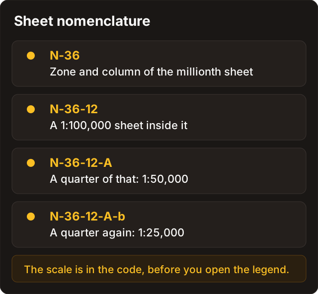
Sheet nomenclature: finding neighbours and related scales
Nomenclature is not a technical detail but the key to searching. It is how you find adjoining sheets, check whether a road or river continues, look for a larger scale and locate alternative editions.
The manual sets out the layout and nomenclature in which the 1:1,000,000 sheet is the base: its border measures 4° of latitude by 6° of longitude, with belts lettered in Latin characters and columns numbered. For 1:100,000 the million sheet is divided into 144 parts, each 20' of latitude by 30' of longitude; 1:50,000 comes from dividing the 1:100,000 sheet into four parts А, Б, В, Г, and 1:25,000 from dividing the 1:50,000 sheet again into four parts а, б, в, г. This describes the system as set out in that manual; with a specific archival sheet in front of you, verify the nomenclature against its own border and edition.
| Example structure | What you can do with it |
|---|---|
M-36 | Find the million sheet and see its broad geographic coverage |
M-36-136 | Find the 1:100,000 sheet and its neighbours; check whether a feature simply ends at the border |
M-36-136-В | Find the matching 1:50,000 sheet and compare it with the broader one |
M-36-136-В-г | Find the more detailed 1:25,000 continuation — if that edition exists |
Do not reconstruct nomenclature by eye when the scan does not show the border: find the full sheet or a catalogue instead. An adjoining sheet is especially useful when a feature runs into the border — a line, a label or a boundary may continue differently from what a cropped fragment suggests.
The border and its two grids: degrees are not kilometres
A military topographic sheet usually carries two different systems of orientation side by side.
| What you see | What it usually means | How to use it |
|---|---|---|
| Minute and second divisions on the outer border | Geographic coordinates: latitude and longitude | For global position and for finding the sheet |
| Labelled lines inside the sheet | A rectangular kilometre grid of a specific system | For local measurement — only once you understand the zone and the system |
| Zone number, marginal notes, an additional grid | Service data linking the sheet to an adjoining zone or system | Do not ignore them: they explain discrepancies in labels and coordinates |
| Ticks and dashes on the border | Divisions belonging to the border and its coordinate information | Do not mistake them for feature symbols |
The manual states that the outer border of large-scale sheets is divided into minute intervals, and separately describes the lines of the adjoining zone and the differences that applied before 1961. For a Discovera reader the point is not the arithmetic but the discipline: do not type coordinates into an app until you know which grid you are looking at.
Practical rule. If all you have is a crop with no border, do not present a coordinate as exact. Record it as an approximate visual reference and go and find the full sheet.
Symbols: position, size and explanation
An archival topographic map is a system of signs, not a miniature photograph. The same feature may appear as an outline, as an enlarged symbol, or as a symbol plus a label. An out-of-scale symbol does not depict the size of the feature: its main point gives the position within that map's conventions. How the lettering and abbreviations themselves work is covered in labels, abbreviations and lettering.
| Group of symbols | What to check first | A typical error |
|---|---|---|
| Settlements | Outer outline, street pattern, labels, density, the sheet date | Treating the number of drawn houses as the real number of buildings |
| Individual objects | The main point of the symbol, the explanatory label, the scale | Treating the size of the symbol as the size of the mill, tree, well or station |
| Roads | Line type, surface labels, bridges, continuation on the adjoining sheet | Taking the edge of the road symbol for the real edge of the carriageway |
| Hydrography | Direction, labels, marshland, bridges and fords, the map year | Treating a channel on the sheet as modern and unchanged |
| Relief | Contours, spot heights, hachures, slopes and catchment | Looking for a “rampart” where a natural slope or gully is drawn |
| Ground and vegetation | Outline, repetition of the symbol, labels on type and character | Using an old marsh symbol as proof that the ground is passable today |
Roads, water, relief and settlements
Roads
Symbols and labels can tell you not only where a road ran but its class, surface material, width or number of tracks. The manual gives a specific warning, though: on metalled roads the middle between the two lines of the symbol corresponds to the middle of the road on the ground, while the lines themselves are in most cases not the edges of the road.
For an overlay this is a decisive limitation: if the edge of the symbol does not match the satellite road, that alone does not prove the historical layer has slipped. Compare the centreline first, then junctions, bridges and the logical links to settlements and relief. Linear features are covered in more depth in roads, crossings and lines.
Water
A stream, a canal, a lake, a marsh, a pond, an oxbow and a seasonal watercourse are different objects, but their symbols still record the state of things at the date of the source. Channels may have been straightened, flooded, drained or reshaped by natural processes. On a historical map water is a strong lead for a hypothesis, but not an unconditional control point for georeferencing.
Relief
Relief outlasts most structures, but the way it is drawn depends on the scale and the series. A spot height belongs to one point and a contour to a line of equal height; together they let you test whether a road, stream, hollow, gully or ridge has been read sensibly. Do not derive an archaeological feature from a shadow, a hachure or a faint line alone: check the legend, the direction of slope and the adjoining sheet first. Reading the landscape as a whole is covered in relief, water and time.
Settlements
For densely built-up places the map shows mainly the outer outline, the main streets and some of the buildings; the number of houses drawn is not necessarily the number of buildings that stood there. So do not turn a single small square into proof of a specific house, and do not treat the absence of a symbol as proof that no settlement existed at another point in time.
Revision layers and dating the map
A single sheet can carry information from several years at once: the original survey, the compilation, editorial corrections, an overprint, a reissue, a collector's pencil note, a modern digital caption. The map has to be read as a layered document.
| What you notice | Possible explanation | What to do |
|---|---|---|
| A different print colour or a different typeface | An editorial correction, an overprint, a separate thematic layer | Find the date or explanation in the margin and keep it apart from the base survey |
| A line of different weight or raster quality | Redrawing, correction, a scan artefact or damage | Compare with another copy of the same sheet |
| A feature present here but absent on an adjoining edition | The feature changed, a different date, a different revision, or an error | Build a small chronology of sources instead of picking the convenient version |
| The layer looks accurate on one feature and drifts next to it | Local deformation of the sheet, poor georeferencing, uneven accuracy of the source data | Assess the overlay against several independent landmarks |
Write in your notes not “the feature existed in 1942” but something closer to: “on the sheet printed in … and based on … data, the feature is shown with such-and-such a symbol”. That preserves the difference between a documentary observation and a historical conclusion. From there the wording turns into a concrete enquiry — as in the single archival case study.
Overlay checks and a confidence record
For RKKA and General Staff sheets the principle is the same as for any old map: a handsome match does not replace a check. Take several independent landmarks and record where the layer is reliable and where it is not. The full protocol is in seven overlay checks; how it looks on a phone is in old maps on your phone.
| Field in Discovera | How to fill it |
|---|---|
| Source | “RKKA or General Staff map, nomenclature …, scale …, edition …” |
| Sheet passport | Survey, compilation, printing, revisions — only what is actually stated |
| Feature | “A linear symbol labelled …”, not “an old road” straight away |
| Checks | Legend, adjoining sheet, larger scale, relief, a map of another year |
| Georeferencing | Which landmarks matched and where on the sheet the overlay diverges |
| Confidence | High, medium or low — with a one-line reason |
| Legal status | Checked separately; a historical sheet is not permission to enter or to disturb the ground |
A map sheet is not a permission
A map answers the question “what was shown here”, not the question “what may be done here”. Nomenclature, a printing year and a neatly matching overlay create neither a right of access to a parcel, nor a right to disturb the ground, nor grounds for treating a place as unprotected.
Law and ethics. A map grants no permission. The legal regime of the parcel, the status of the site and the access procedure are checked separately from the cartographic work. At any sign of a cultural layer, a burial or ordnance, work stops on the spot and the local reporting procedure takes over, not your own judgement.
Where an amateur has to stop is set out in test pits and boundaries and in legal status. Getting from the map to the documents runs through the archives of Russia and Belarus — described there for readers who search in those countries, since that is where a sheet nomenclature and a feature name become a checkable enquiry.
FAQ
Is every Soviet military map a “General Staff map”?
In conversation people often say so, but research needs the exact imprint. Record what is printed on the sheet: the issuing body, the date, the scale, the nomenclature and the revision. Without that, comparing two sheets against each other is meaningless.
Which scale should I choose for working on an old feature?
Start with the scale that shows how the feature sits in its district, then look for a larger sheet to check it. A more detailed scale does not remove the need to verify the date, the legend and adjoining sources — it only adds detail inside the same set of conventions.
Why doesn't the road line up with the satellite image?
The reasons vary: the road was moved or straightened, the map generalised its line, the overlay is locally deformed, or you are comparing the edge of a symbol rather than the centreline. Check several indications before concluding, and judge the discrepancy against more than one landmark.
Can I take coordinates straight from the kilometre grid?
Only after you understand the system and the zone stated on that particular sheet. Do not confuse the internal rectangular grid with the geographic border in degrees and minutes: they are two different systems, and their labels look deceptively alike.
The feature is on an RKKA sheet. Does that mean it survives?
No. The map confirms only that the feature was drawn from particular source data and in a particular revision. Its present condition, survival, accessibility and legal regime are checked separately and from other sources.
What if the sheet shows no border and no imprint?
Treat such a scan as a lead, not a source. Look for the full sheet in an archive, a library or a catalogue, and verify the nomenclature and the edition. Until the border has been read, any coordinate or measurement taken from that image stays approximate.
Sources
- Military Topographic Directorate of the General Staff — symbols of Soviet topographic maps, 1967 reissue
- Symbols of Soviet topographic maps — appendices: nomenclature, sheet layout and border
- State Archive of the Russian Federation — contacts and enquiry procedure
- Russian State Historical Archive — reference and copying services
- National Archives of the Republic of Belarus
- Archiwum Map Wojskowego Instytutu Geograficznego — topographic sheet collection
- The National Archives (UK) — historical maps